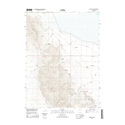
2014 Map of Craner Peak
USGS Topo · Published 2014About this map
Craner Peak and the Lakeside Mountains dominate this high-desert landscape in Tooele County, where the terrain descends toward the Great Salt Lake in the northeast. The map illustrates a stark geographic transition from the high ridges of Jedediah Mtn and Black Mtn down into the broad expanse of Lakeside Valley. These mountain ranges are dissected by numerous drainages, including Mountain Sheep Canyon, Vindicator Canyon, and Monarch Canyon, which provide natural corridors through the otherwise challenging elevation. Human activity in this arid region is tied to utility and resource access, marked by the presence of Rowley and a network of specialized routes such as Marblehead Quarry Rd and Gas Line Rd. The significance of water in this environment is underscored by the location of Craner Spring, a vital point of interest near the southern base of its namesake peak.
Find a feature on this map
40 named features on this map. Tap any name to fly to it.
Don’t see what you’re looking for? This feature index may not catch every label — zoom into the map to look around manually.
Map Details
Editions of this 2014 Craner Peak Map
This is the sole edition of this map. No revisions or reprints were ever made.
Other maps of this area

1885 · Tooele Valley
USGS Topo · 1:250,000

1953 · Tooele
USGS Topo · 1:250,000

1954 · Brigham City
USGS Topo · 1:250,000

1955 · Tooele
USGS Topo · 1:250,000

1958 · Brigham City
USGS Topo · 1:250,000

1962 · Brigham City
USGS Topo · 1:250,000

1968 · Carrington Island SW
USGS Topo · 1:24,000

1968 · Poverty Point
USGS Topo · 1:24,000

1968 · Deardens Knoll
USGS Topo · 1:24,000

1968 · Badger Island NW
USGS Topo · 1:24,000