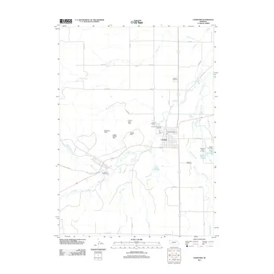
2011 Map of Crawford
USGS Topo · Published 2011About this map
Crawford serves as a central hub in this high-plains landscape, where the confluence of several water systems like the White River and White Clay Creek once supported early ranching and transit. The western portion of the area is dominated by the dramatic geological formations of the Pine Ridge, including Lovers Leap Butte, Red Cloud Buttes, and the distinctively named Giants Coffins Butte. These landmarks overlook the vast grounds of Fort Robinson State Park, a site of significant military and pioneer history.
Find a feature on this map
43 named features on this map. Tap any name to fly to it.
Don’t see what you’re looking for? This feature index may not catch every label — zoom into the map to look around manually.
Map Details
Editions of this 2011 Crawford Map
This is the sole edition of this map. No revisions or reprints were ever made.
Other maps of this area

1955 · Alliance
USGS Topo · 1:250,000

1957 · Alliance
USGS Topo · 1:250,000

1958 · Alliance
USGS Topo · 1:250,000

1980 · Horn
USGS Topo · 1:24,000

1980 · Crow Butte
USGS Topo · 1:24,000

1980 · Smiley Canyon
USGS Topo · 1:24,000
1980 · Roundtop
USGS Topo · 1:24,000

1980 · Dead Mans Creek
USGS Topo · 1:24,000
1980 · Belmont
USGS Topo · 1:24,000
1980 · Crawford
USGS Topo · 1:24,000