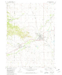
1980 Map of Crawford
USGS Topo · Published 1981About this map
The White River and two major rail lines converge at Crawford, a key high-plains settlement defined by its proximity to significant public lands and military history. Just west of the town site, Fort Robinson State Park preserves the grounds of a notable frontier post, featuring a Museum and the Trailside Museum near the banks of Soldier Creek. The topography is dominated by the Red Cloud Buttes, including distinctive formations like Lovers Leap Butte, Saddle Rock, and Giants Coffins Butte that rise above the river valley. The map reveals a specialized local economy and infrastructure, from the Crawford National Fish Hatchery and local Waterworks to the intersection of the Chicago and North Western and Chicago Burlington and Northern railroads. These transit corridors, alongside numerous Gravel Pits, highlight the late-20th-century development of this Dawes County hub.
Find a feature on this map
35 named features on this map. Tap any name to fly to it.
Don’t see what you’re looking for? This feature index may not catch every label — zoom into the map to look around manually.
Map Details
Editions of this 1980 Crawford Map
This is the sole edition of this map. No revisions or reprints were ever made.
Other maps of this area

1955 · Alliance
USGS Topo · 1:250,000

1957 · Alliance
USGS Topo · 1:250,000

1958 · Alliance
USGS Topo · 1:250,000

1980 · Horn
USGS Topo · 1:24,000

1980 · Crow Butte
USGS Topo · 1:24,000

1980 · Smiley Canyon
USGS Topo · 1:24,000
1980 · Roundtop
USGS Topo · 1:24,000

1980 · Dead Mans Creek
USGS Topo · 1:24,000
1980 · Belmont
USGS Topo · 1:24,000
1980 · Whitney
USGS Topo · 1:24,000