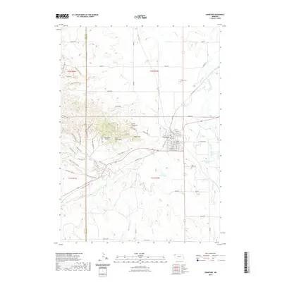
2021 Map of Crawford
USGS Topo · Published 2021About this map
The town of Crawford sits at a geographic crossroads in Dawes County, where the plains meet the striking formations of the Nebraska Panhandle. This modern survey illustrates the proximity of the community to geological landmarks such as Red Cloud Buttes and Lovers Leap Butte, while highlighting the importance of water management through sites like Lake Crawford and the McDowell Reservoir Number 1. For those researching local heritage, the map identifies both the Crawford Cem and Saint John Cem, along with a dense network of trails including the Wagon Wheel Trl and Houston's Cabin Trl. The drainage of the White River and its various tributaries like Spring Cr and White Clay Cr remains central to the area's landscape, defining the rural character of the region.
Find a feature on this map
84 named features on this map. Tap any name to fly to it.
Don’t see what you’re looking for? This feature index may not catch every label — zoom into the map to look around manually.
Map Details
Editions of this 2021 Crawford Map
This is the sole edition of this map. No revisions or reprints were ever made.
Other maps of this area

1955 · Alliance
USGS Topo · 1:250,000

1957 · Alliance
USGS Topo · 1:250,000

1958 · Alliance
USGS Topo · 1:250,000

1980 · Horn
USGS Topo · 1:24,000

1980 · Crow Butte
USGS Topo · 1:24,000

1980 · Smiley Canyon
USGS Topo · 1:24,000
1980 · Roundtop
USGS Topo · 1:24,000

1980 · Dead Mans Creek
USGS Topo · 1:24,000
1980 · Belmont
USGS Topo · 1:24,000
1980 · Crawford
USGS Topo · 1:24,000