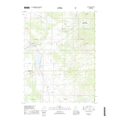
2019 Map of Crawford
USGS Topo · Published 2019About this map
Crawford and the surrounding high country of Delta Co and Montrose Co reveal a landscape defined by an intricate network of irrigation and the peaks of the West Elk Mountains. The town is situated on a plateau where the Grand View Ditch and Fruitland Mesa Ditch suggest a long history of water management essential for ranching and agriculture in this environment. To the east, the terrain rises sharply into the Gunnison National Forest, dominated by Saddle Mtn and the distinct volcanic plug of Needle Rock. For genealogists, the map identifies the Crawford Cem near town and the more isolated Collins Family Cem overlooking the Clear Fork. The presence of the Gould Canal and Cattlemans Ditch further south near Maher illustrates how early settlers utilized every available water source from the Smith Fork and Crawford Reservoir to sustain their livestock and homesteads on the Missouri Flats.
Find a feature on this map
50 named features on this map. Tap any name to fly to it.
Don’t see what you’re looking for? This feature index may not catch every label — zoom into the map to look around manually.
Map Details
Editions of this 2019 Crawford Map
This is the sole edition of this map. No revisions or reprints were ever made.
Other maps of this area

1938 · Mt. Gunnison
USGS Topo · 1:48,000

1945 · Mount Gunnison
USGS Topo · 1:62,500

1956 · Montrose
USGS Topo · 1:250,000

1957 · Cathedral Peak
USGS Topo · 1:24,000

1957 · X Lazy F Ranch
USGS Topo · 1:24,000

1957 · Grizzly Ridge
USGS Topo · 1:24,000

1959 · Montrose
USGS Topo · 1:250,000

1960 · Montrose
USGS Topo · 1:250,000

1964 · Minnesota Pass
USGS Topo · 1:24,000

1965 · Mount Guero
USGS Topo · 1:24,000