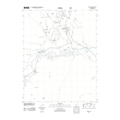
2011 Map of Creede
USGS Topo · Published 2011About this map
The town of Creede and the surrounding mineral-rich mountains define this region of the San Juan Mountains during the early twenty-first century. This survey documents a landscape heavily shaped by its silver mining history, with a high concentration of mining operations north of the settlement. Significant sites like the Commodore Mine, Nelson Tunnel Mine, and Emperius Mine sit along West Willow Creek and East Willow Creek, while the Bulldog Mountain area shows modern environmental management infrastructure such as the Upper Homestake Tailings Pond Dam. To the south, the terrain levels out at Sixmile Flats and Moonshine Mesa, where the Rio Grande flows past Wason Ranch. The presence of the Creede Airstrip and Mineral County Memorial Airport near the river underscores the transition from industrial mining to a more modern infrastructure network, while Marshall Park Campground highlights the area's role in mountain recreation.
Find a feature on this map
67 named features on this map. Tap any name to fly to it.
Don’t see what you’re looking for? This feature index may not catch every label — zoom into the map to look around manually.
Map Details
Editions of this 2011 Creede Map
This is the sole edition of this map. No revisions or reprints were ever made.
Other maps of this area

1905 · San Cristobal
USGS Topo · 1:125,000

1907 · San Cristobal
USGS Topo · 1:125,000

1914 · Creede
USGS Topo · 1:125,000

1916 · Creede
USGS Topo · 1:125,000

1945 · Durango
USGS Topo · 1:250,000

1953 · Durango
USGS Topo · 1:250,000

1954 · Durango
USGS Topo · 1:250,000

1957 · Spar City
USGS Topo · 1:62,500

1959 · Creede
USGS Topo · 1:62,500

1959 · Bristol Head
USGS Topo · 1:62,500