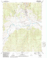
1986 Map of Creede
USGS Topo · Published 1986About this map
Mining operations and narrow-gauge rail lines define the landscape around Creede in the mid-1980s. The town sits at the mouth of a deep canyon where Willow Creek meets the broader valley of the Rio Grande, a site historically shaped by silver extraction. Numerous shafts and prospects dot the hillsides, including the Commodore Tunnel and Monon Mine, while the former Sunnyside settlement remains marked only as a site further west.
Find a feature on this map
50 named features on this map. Tap any name to fly to it.
Don’t see what you’re looking for? This feature index may not catch every label — zoom into the map to look around manually.
Map Details
Editions of this 1986 Creede Map
This is the sole edition of this map. No revisions or reprints were ever made.
Other maps of this area

1905 · San Cristobal
USGS Topo · 1:125,000

1907 · San Cristobal
USGS Topo · 1:125,000

1914 · Creede
USGS Topo · 1:125,000

1916 · Creede
USGS Topo · 1:125,000

1945 · Durango
USGS Topo · 1:250,000

1953 · Durango
USGS Topo · 1:250,000

1954 · Durango
USGS Topo · 1:250,000

1957 · Spar City
USGS Topo · 1:62,500

1959 · Creede
USGS Topo · 1:62,500

1959 · Bristol Head
USGS Topo · 1:62,500