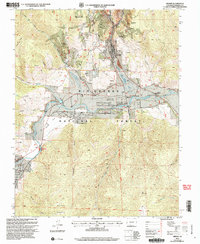
2001 Map of Creede
USGS Topo · Published 2005About this map
Creede and the neighboring settlement of North Creede anchor this mountain landscape within the Rio Grande National Forest. The map documents a town deeply tied to its industrial heritage, with the presence of Bulldog Tunnel, Resurrection Tunnel, and the Monon Mine illustrating the extensive silver mining infrastructure that shaped the region. Near the bend of the Rio Grande, the Mineral County Memorial Airport and the historic Wason Ranch highlight the local transition toward modern transportation and traditional ranching. The terrain is marked by prominent landmarks such as Bulldog Mountain and The Snowshoe, while the high-altitude hydrology is defined by Willow Creek and Miners Creek. Genealogists may find value in the location of the local Cem and the Sunnyside (Site), providing a record of human occupation and labor at the start of the twenty-first century.
Find a feature on this map
42 named features on this map. Tap any name to fly to it.
Don’t see what you’re looking for? This feature index may not catch every label — zoom into the map to look around manually.
Map Details
Editions of this 2001 Creede Map
This is the sole edition of this map. No revisions or reprints were ever made.
Other maps of this area

1905 · San Cristobal
USGS Topo · 1:125,000

1907 · San Cristobal
USGS Topo · 1:125,000

1914 · Creede
USGS Topo · 1:125,000

1916 · Creede
USGS Topo · 1:125,000

1945 · Durango
USGS Topo · 1:250,000

1953 · Durango
USGS Topo · 1:250,000

1954 · Durango
USGS Topo · 1:250,000

1957 · Spar City
USGS Topo · 1:62,500

1959 · Creede
USGS Topo · 1:62,500

1959 · Bristol Head
USGS Topo · 1:62,500