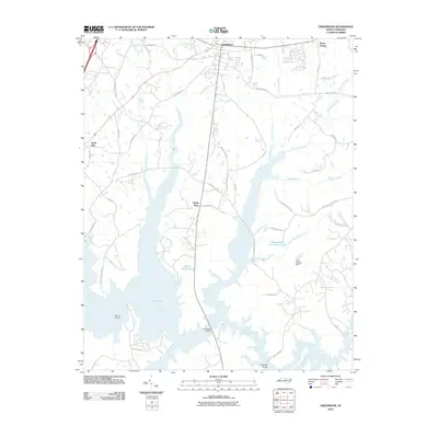
2010 Map of Creedmoor
USGS Topo · Published 2010About this map
The Creedmoor area in Granville County is defined by the complex intersection of the northern reaches of Falls Lake and the original course of the Neuse River. This 2010 survey illustrates how the landscape was altered by large-scale water management, with the reservoir's fingers extending into various drainages like Ledge Creek and Lick Creek. These flooded valleys sit alongside established small communities such as Mount Energy and Sandy Plain, reflecting the region's balance between rural settlement and modern infrastructure development. Local landmarks such as Boyces Bridge and Lawrences Bridge serve as critical crossing points over the expansive lake waters, while smaller impoundments like Spring Valley Lake and Willowhaven Lake Number One dot the surrounding terrain. The road network, including historic routes like Old Weaver Trl and Light Horse Trl, provides a detailed view of the area's layout prior to more intensive suburban expansion from the south.
Find a feature on this map
52 named features on this map. Tap any name to fly to it.
Don’t see what you’re looking for? This feature index may not catch every label — zoom into the map to look around manually.
Map Details
Editions of this 2010 Creedmoor Map
This is the sole edition of this map. No revisions or reprints were ever made.
Other maps of this area

1943 · Durham South
USGS Topo · 1:62,500

1943 · Raleigh
USGS Topo · 1:62,500

1943 · Creedmoor
USGS Topo · 1:62,500

1944 · Creedmoor
USGS Topo · 1:62,500

1951 · Raleigh
USGS Topo · 1:62,500

1951 · Durham South
USGS Topo · 1:62,500

1951 · Durham North
USGS Topo · 1:62,500

1953 · Raleigh
USGS Topo · 1:250,000

1953 · Greensboro
USGS Topo · 1:250,000

1954 · Greensboro
USGS Topo · 1:250,000