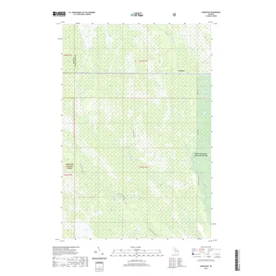
2019 Map of Creighton
USGS Topo · Published 2019About this map
Creighton sits along the M-28 corridor in this northern Michigan landscape, where the managed timberlands of the Hiawatha National Forest meet the protected wetlands of the Seney National Wildlife Refuge. The terrain is defined by a complex drainage network, primarily the Creighton River and the W Br Manistique River, which flow through extensive lowlands such as Creighton Marsh. This 2019 survey documents a region where transportation is heavily tied to the forest economy and conservation management. Logging and service roads like Hickey Creek Truck Trl and Creighton Truck Trl crisscross the townships of t46n r16w and t45n r16w, providing access to remote reaches of the Alger and Schoolcraft county line.
Find a feature on this map
23 named features on this map. Tap any name to fly to it.
Don’t see what you’re looking for? This feature index may not catch every label — zoom into the map to look around manually.
Map Details
Editions of this 2019 Creighton Map
This is the sole edition of this map. No revisions or reprints were ever made.
Other maps of this area

1931 · Steuben NE
USGS Topo · 1:31,680

1931 · Shingleton SW
USGS Topo · 1:31,680

1931 · Steuben NW
USGS Topo · 1:31,680

1931 · Manistique River NW
USGS Topo · 1:31,680

1931 · Shingleton NE
USGS Topo · 1:31,680

1931 · Driggs Lake NW
USGS Topo · 1:31,680

1931 · Shingleton SE
USGS Topo · 1:31,680

1931 · Driggs Lake SW
USGS Topo · 1:31,680

1958 · Shingleton
USGS Topo · 1:62,500
1958 · Steuben
USGS Topo · 1:62,500