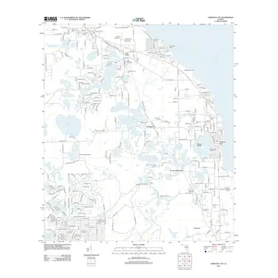
2012 Map of Crescent City
USGS Topo · Published 2012About this map
Crescent City and the surrounding citrus and water-rich landscape of Putnam County are defined here by a chain of inland lakes and the wide expanse of Crescent Lake to the east. The settlement pattern follows the CSX railroad corridor, which links the established community at Lake Como through Huntington and Crescent City Station down toward Hammond. This 2012 survey illustrates the long-standing agricultural and transport hubs of the region, including the Skinners Wholesale Nursery Airport and local aviation sites like Eagles Nest Aerodrome and Finlay Farm Airport. Local history and genealogy are anchored by several notable burial grounds, including Pomona-Lake Como Cem and Greenwood Cem, alongside the Eden Ch church. The map documents the intricate hydrology of the area, from Lake Broward in the north to the western reach of the Saint Johns River, showing how water has dictated the placement of towns and transit for generations.
Find a feature on this map
259 named features on this map. Tap any name to fly to it.
Don’t see what you’re looking for? This feature index may not catch every label — zoom into the map to look around manually.
Map Details
Editions of this 2012 Crescent City Map
This is the sole edition of this map. No revisions or reprints were ever made.
Other maps of this area

1912 · Palatka
USGS Topo · 1:48,000

1915 · Palatka
USGS Topo · 1:62,500

1937 · Dinner Island
USGS Topo · 1:48,000

1943 · Dinner Island
USGS Topo · 1:62,500

1944 · Dinner Island
USGS Topo · 1:62,500

1954 · Daytona Beach
USGS Topo · 1:250,000

1958 · Daytona Beach
USGS Topo · 1:250,000

1964 · Daytona Beach
USGS Topo · 1:250,000
1968 · Satsuma
USGS Topo · 1:24,000
1968 · San Mateo
USGS Topo · 1:24,000