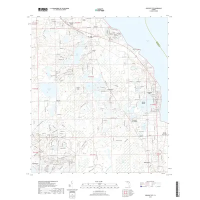
2018 Map of Crescent City
USGS Topo · Published 2018About this map
Crescent City sits prominently between the broad waters of Crescent Lake and Stella Lake, anchoring a chain of lakeside settlements in northern Florida. This region is characterized by a high density of named water bodies, including Como Lake, Lake Broward, and Margaret Lake, which have long defined the area's development and transport patterns. The CSX Transportation rail line runs north-south, connecting towns like Pomona Park and Huntington while passing through Crescent City Station. Aviation history is visible through several small fields such as Thunderbird Air Park, Eagles Nest Aerodrome, and the Jim Finlay Farm Airport. Smaller communities like Denver and Hammond are mapped to the south, while Georgetown marks the southwestern edge near the wetlands of Tiger Branch. The proximity of local cemeteries, such as Eden Cem and Argenta Cem, provides valuable points of interest for genealogical research in this long-settled citrus and agricultural region.
Find a feature on this map
213 named features on this map. Tap any name to fly to it.
Don’t see what you’re looking for? This feature index may not catch every label — zoom into the map to look around manually.
Map Details
Editions of this 2018 Crescent City Map
This is the sole edition of this map. No revisions or reprints were ever made.
Other maps of this area

1912 · Palatka
USGS Topo · 1:48,000

1915 · Palatka
USGS Topo · 1:62,500

1937 · Dinner Island
USGS Topo · 1:48,000

1943 · Dinner Island
USGS Topo · 1:62,500

1944 · Dinner Island
USGS Topo · 1:62,500

1954 · Daytona Beach
USGS Topo · 1:250,000

1958 · Daytona Beach
USGS Topo · 1:250,000

1964 · Daytona Beach
USGS Topo · 1:250,000
1968 · Satsuma
USGS Topo · 1:24,000
1968 · San Mateo
USGS Topo · 1:24,000