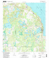
1994 Map of Crescent City
USGS Topo · Published 1998About this map
The town of Crescent City sits prominently on the eastern edge of this region, anchored by the waters of Crescent Lake and Lake Stella. The landscape is defined by its complex hydrology, where numerous lakes including Lake Como, Silver Lake, and Clear Lake are interspersed with the expansive Lake George State Wildlife Management Area. This 1994 photoinspection preserves the layout of established citrus-era settlements such as Huntington, Pomona Park, and Denver, while also documenting the transportation network of the day, from the Crescent City Station railroad stop to the Thunderbird Airpark landing strip.
Find a feature on this map
39 named features on this map. Tap any name to fly to it.
Don’t see what you’re looking for? This feature index may not catch every label — zoom into the map to look around manually.
Map Details
Editions of this 1994 Crescent City Map
This is the sole edition of this map. No revisions or reprints were ever made.
Other maps of this area

1912 · Palatka
USGS Topo · 1:48,000

1915 · Palatka
USGS Topo · 1:62,500

1937 · Dinner Island
USGS Topo · 1:48,000

1943 · Dinner Island
USGS Topo · 1:62,500

1944 · Dinner Island
USGS Topo · 1:62,500

1954 · Daytona Beach
USGS Topo · 1:250,000

1958 · Daytona Beach
USGS Topo · 1:250,000

1964 · Daytona Beach
USGS Topo · 1:250,000
1968 · Satsuma
USGS Topo · 1:24,000
1968 · San Mateo
USGS Topo · 1:24,000