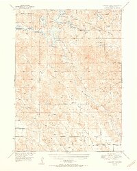
1950 Map of Crescent Lake
USGS Topo · Published 1950About this map
Crescent Lake National Wildlife Refuge anchors this mid-century survey of Garden County, Nebraska, showcasing a complex system of alkaline and freshwater lakes within the Sandhills. The landscape is defined by its water bodies, including Crescent Lake, Hackberry Lake, and Island Lake, which have historically served as critical migratory stops. Beyond the refuge boundaries, the map reveals a sparsely populated ranching country where life centered around isolated outposts and schoolhouses. Scattered rural institutions like Dogtown Flats Sch, Lone Star Sch, and Evergreen Ch suggest the distributed nature of the community during this era. Topographical markers such as Old Lady Beam Hill and Sugar Loaf Hill rise above the valleys, while the courses of Blue Creek and Lost Creek trace the drainage patterns of this unique high-plains ecosystem before later 20th-century developments altered the local hydrology.
Find a feature on this map
32 named features on this map. Tap any name to fly to it.
Don’t see what you’re looking for? This feature index may not catch every label — zoom into the map to look around manually.
Map Details
Editions of this 1950 Crescent Lake Map
3 editions found
Other maps of this area

1896 · Browns Creek
USGS Topo · 1:125,000

1899 · Browns Creek
USGS Topo · 1:125,000

1899 · Sidney
USGS Topo · 1:125,000

1900 · Chappell
USGS Topo · 1:125,000

1949 · Mumper
USGS Topo · 1:62,500

1949 · Rackett
USGS Topo · 1:62,500

1950 · Crescent Lake
USGS Topo · 1:62,500

1950 · Storm Lake
USGS Topo · 1:62,500

1950 · Longfellow Lake
USGS Topo · 1:62,500

1951 · Rackett
USGS Topo · 1:62,500