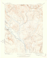
1888 Map of Crested Butte
USGS Topo · Published 1956About this map
The mining and supply town of Crested Butte sits at the heart of this survey, serving as a critical terminus for the Denver and Rio Grande Railroad. This late-19th-century landscape is defined by the heavy reliance on these rails to connect the high-altitude camps of the Elk Mountains to broader markets. To the north, the settlement of Gothic marks a hub of activity near the confluence of Copper Creek and East River, while the surrounding terrain is etched with the names of early landmarks like Washington Gulch and Meridian Lake. The map reveals a rugged geography of high passes and basins, including Pearl Pass along the Saw-Tooth Range, where early mineral exploration was at its peak. Waterways such as the Slate River and Cement Creek provide the drainage for these jagged peaks, illustrating the natural obstacles overcome by the industrial expansion of the era.
Find a feature on this map
52 named features on this map. Tap any name to fly to it.
Don’t see what you’re looking for? This feature index may not catch every label — zoom into the map to look around manually.
Map Details
Editions of this 1888 Crested Butte Map
2 editions found
Other maps of this area

1888 · Crested Butte
USGS Topo · 1:62,500

1888 · Anthracite
USGS Topo · 1:62,500

1889 · Crested Butte
USGS Topo · 1:62,500

1889 · Anthracite
USGS Topo · 1:62,500

1893 · Anthracite
USGS Topo · 1:62,500

1893 · Crested Butte
USGS Topo · 1:62,500

1893 · Aspen
USGS Topo · 1:62,500

1894 · Anthracite
USGS Topo · 1:62,500

1895 · Aspen
USGS Topo · 1:62,500

1909 · Mount Jackson
USGS Topo · 1:125,000