
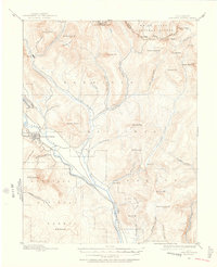
1888 Map of Crested Butte
USGS Topo · Published 1888About this map
Crested Butte stands as the primary hub of this high-altitude landscape surveyed in the late 1880s, situated at the confluence of several glacial valleys. The town is tied to the outside world via the Denver and Rio Grande Railroad, which follows the narrow corridor of the Slate River. This layout reflects an economy transitioning from high-mountain prospecting to the industrial extraction of coal, noted by the presence of (Anthracite) along the western edge. North of the main settlement, the mining camp of Gothic is nestled near Avery Peak, serving as a gateway to the peaks of the Saw Tooth Range. The map documents a complex network of trails and roads crossing high saddles like Taylor Pass and Pearl Pass, connecting remote watersheds such as Cement Creek and East Brush Creek.
Find a feature on this map
49 named features on this map. Tap any name to fly to it.
Don’t see what you’re looking for? This feature index may not catch every label — zoom into the map to look around manually.
Map Details
Editions of this 1888 Crested Butte Map
2 editions found
Other maps of this area

1888 · Anthracite
USGS Topo · 1:62,500

1889 · Crested Butte
USGS Topo · 1:62,500

1889 · Anthracite
USGS Topo · 1:62,500

1893 · Anthracite
USGS Topo · 1:62,500

1893 · Crested Butte
USGS Topo · 1:62,500

1893 · Aspen
USGS Topo · 1:62,500

1894 · Anthracite
USGS Topo · 1:62,500

1895 · Aspen
USGS Topo · 1:62,500

1909 · Mount Jackson
USGS Topo · 1:125,000

1911 · Mount Jackson
USGS Topo · 1:125,000