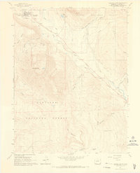
1961 Map of Crested Butte
USGS Topo · Published 1969About this map
Crested Butte sits at the northern edge of this high-altitude landscape, where Coal Creek meets the Slate River. In the early 1960s, the town's footprint remained compact, surrounded by the reaching boundaries of the Gunnison National Forest. Evidence of the region’s extractive and agricultural history is etched into the terrain, from the Bulkley Mine (Site) on the slopes of Baxter Gulch to the complex network of irrigation channels like the Verzuh Ditch and Dillsworth Ditch. An Old Railroad Grade snakes along the river valleys, marking the path of former industry through the meadows of Cold Spring Ranch and toward Strand Hill. The southern portion of the sheet is defined by the massive profiles of Whetstone Mtn and Red Mountain, separated by the deep drainage of Carbon Creek. This survey captures the transition of the valley from a mining and ranching hub toward its modern character, evidenced by the presence of Skyland Camp near Lake Grant.
Find a feature on this map
38 named features on this map. Tap any name to fly to it.
Don’t see what you’re looking for? This feature index may not catch every label — zoom into the map to look around manually.
Map Details
Editions of this 1961 Crested Butte Map
4 editions found
Other maps of this area

1888 · Crested Butte
USGS Topo · 1:62,500

1888 · Anthracite
USGS Topo · 1:62,500

1889 · Crested Butte
USGS Topo · 1:62,500

1889 · Anthracite
USGS Topo · 1:62,500

1893 · Anthracite
USGS Topo · 1:62,500

1893 · Crested Butte
USGS Topo · 1:62,500

1894 · Anthracite
USGS Topo · 1:62,500

1956 · Montrose
USGS Topo · 1:250,000

1959 · Montrose
USGS Topo · 1:250,000

1960 · Montrose
USGS Topo · 1:250,000