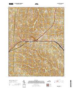
2019 Map of Crewe West
USGS Topo · Published 2019About this map
Burkeville serves as a central hub on this landscape, where major routes converge amidst a network of rural settlements like Burkes Tavern and Mutt. The terrain is defined by the headwaters of numerous creeks, including Flat Cr, Deep Cr, and Ellis Cr, which carve through the undulating countryside of Nottoway and Prince Edward counties. For those researching local families, the map is densely marked with family-named burial grounds such as Cook Cem, Downs Cem, and Vaughns Cem, alongside larger community sites like Sunset Hill Cem. To the east, the edge of Crewe is visible, connected by historical corridors like Jennings Ordinary Rd. The landscape south of the main settlements gives way to the drainage of the Little Nottoway River, illustrating the agricultural and creek-bottom character of the Southside Virginia region.
Find a feature on this map
100 named features on this map. Tap any name to fly to it.
Don’t see what you’re looking for? This feature index may not catch every label — zoom into the map to look around manually.
Map Details
Editions of this 2019 Crewe West Map
This is the sole edition of this map. No revisions or reprints were ever made.
Other maps of this area

1891 · Farmville
USGS Topo · 1:125,000

1893 · Farmville
USGS Topo · 1:125,000

1947 · Roanoke
USGS Topo · 1:250,000

1958 · Farmville
USGS Topo · 1:62,500

1958 · Jetersville
USGS Topo · 1:62,500

1958 · Crewe
USGS Topo · 1:62,500

1958 · Keysville
USGS Topo · 1:62,500

1959 · Roanoke
USGS Topo · 1:250,000

1963 · Roanoke
USGS Topo · 1:250,000
1968 · Deatonville
USGS Topo · 1:24,000