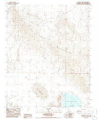
1986 Map of Cronese Lakes
USGS Topo · Published 1986About this map
West Cronese Lake and East Cronese Lake occupy the floor of the Cronese Valley in this mid-1980s topographic study. The landscape is defined by the sharp transition from the dry lake basins to the towering Soda Mountains in the north and the smaller Cronese Mountains that separate the two lake beds. This environment is characterized by its aridity, with Bitter Spring serving as a rare water source in a region primarily traversed by 4wd trails. The map detail reflects the harsh desert geography of the Mojave, where traditional settlements are absent, replaced by isolated survey markers such as Vfgc 5-238 and Vfgc 1-181. For those studying California desert history, the map provides a clear record of the area's internal drainage systems and natural topography before modern shifts in desert management.
Find a feature on this map
19 named features on this map. Tap any name to fly to it.
Don’t see what you’re looking for? This feature index may not catch every label — zoom into the map to look around manually.
Map Details
Editions of this 1986 Cronese Lakes Map
This is the sole edition of this map. No revisions or reprints were ever made.
Other maps of this area

1933 · Avawatz Mountains
USGS Topo · 1:250,000

1947 · Trona
USGS Topo · 1:250,000

1948 · Red Pass Lake
USGS Topo · 1:62,500

1948 · Trona
USGS Topo · 1:250,000

1948 · Cave Mountain
USGS Topo · 1:62,500

1951 · Cave Mountain
USGS Topo · 1:62,500

1951 · Red Pass Lake
USGS Topo · 1:62,500

1953 · Trona
USGS Topo · 1:250,000
1956 · Soda Lake
USGS Topo · 1:62,500

1956 · Baker
USGS Topo · 1:62,500