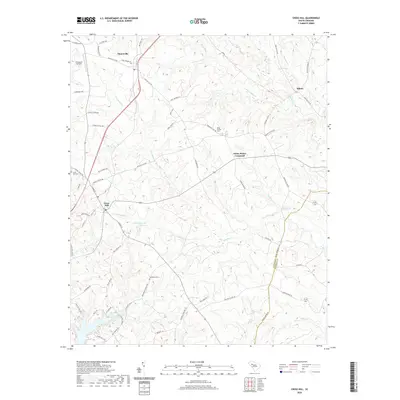
2020 Map of Cross Hill
USGS Topo · Published 2020About this map
Cross Hill and Mountville anchor this southern Laurens County landscape, where the terrain is defined by a dense network of creek drainages feeding into the Little River. The settlement pattern reflects deep-rooted local history, with small clusters like Milton and White Plains Crossroad connected by a web of rural routes. Genealogists will find significant value in the documentation of several burial grounds, including Head Springs Cem, Cross Hill Cem, and Bethabara Cem, which serve as vital markers of early community life. Notable hydrographic features such as Hollingworths Pond and the winding courses of Mudlick Cr and Campbell Cr illustrate the drainage of the Piedmont towards the Newberry County line. Small-scale infrastructure like Thomason Airfield adds modern context to this primarily agricultural and residential area.
Find a feature on this map
71 named features on this map. Tap any name to fly to it.
Don’t see what you’re looking for? This feature index may not catch every label — zoom into the map to look around manually.
Map Details
Editions of this 2020 Cross Hill Map
This is the sole edition of this map. No revisions or reprints were ever made.
Other maps of this area

1892 · Abbeville
USGS Topo · 1:125,000

1941 · Spartanburg
USGS Topo · 1:250,000

1949 · Ninety-Six
USGS Topo · 1:24,000

1953 · Spartanburg
USGS Topo · 1:250,000

1954 · Greenville
USGS Topo · 1:250,000

1958 · Greenville
USGS Topo · 1:250,000

1960 · Spartanburg
USGS Topo · 1:250,000

1963 · Spartanburg
USGS Topo · 1:250,000

1964 · Spartanburg
USGS Topo · 1:250,000
1970 · Bush River
USGS Topo · 1:24,000