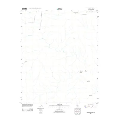
2012 Map of Cross Mountain
USGS Topo · Published 2012About this map
Kelso Valley defines the western reaches of this Kern County landscape, where the intersection of Kelso Valley Rd and Jawbone Canyon Rd facilitates movement through the arid terrain. This 2012 survey illustrates a topography of high summits and drainage systems, anchored by Cross Mountain and White Mountain in the east. The seasonal hydrology is marked by Cottonwood Cr and the isolated Braitman Spring, suggesting the critical importance of water sources in this high-desert environment. Further south, Antimony Flat and Little Jawbone Canyon reveal the complex geological character of the region. The map preserves the names of specific peaks like Hoffman Summit and Toms Hill, providing a clear record of the area's named landmarks before later modern developments or boundary shifts.
Find a feature on this map
12 named features on this map. Tap any name to fly to it.
Don’t see what you’re looking for? This feature index may not catch every label — zoom into the map to look around manually.
Map Details
Editions of this 2012 Cross Mountain Map
This is the sole edition of this map. No revisions or reprints were ever made.
Other maps of this area

1915 · Mojave
USGS Topo · 1:125,000

1943 · Tehachapi
USGS Topo · 1:62,500

1943 · Cross Mountain
USGS Topo · 1:62,500

1943 · Emerald Mtn
USGS Topo · 1:62,500

1943 · Mojave
USGS Topo · 1:62,500

1948 · Bakersfield
USGS Topo · 1:250,000

1955 · Bakersfield
USGS Topo · 1:250,000

1956 · Bakersfield
USGS Topo · 1:250,000
1956 · Mojave
USGS Topo · 1:62,500

1960 · Bakersfield
USGS Topo · 1:250,000