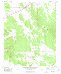
1980 Map of Cross Mountain
USGS Topo · Published 1980About this map
The Juniper Mountains dominate this high-desert landscape in northern Arizona, where water management defines the footprint of human activity. This 1980 survey reveals a sophisticated network of ranching infrastructure, including numerous tanks such as Jack Webb Tank, Shorty Davis Tank, and Hoggy John Tank. These features, along with Cross Mountain Dam and Cooksie Dam, suggest a long-standing reliance on surface water collection to support livestock across the Seventyfour Plains and the rugged drainage of Trout Creek. Local landmarks like Pickett Coral and family-named features like Barney Well offer specific points of interest for genealogists and researchers tracing the history of land use in Yavapai County. The terrain transitions from the volcanic high points of Cross Mtn toward the south into the natural boundary of Dividing Canyon, providing a clear view of the region's topography before more modern development.
Find a feature on this map
21 named features on this map. Tap any name to fly to it.
Don’t see what you’re looking for? This feature index may not catch every label — zoom into the map to look around manually.
Map Details
Editions of this 1980 Cross Mountain Map
This is the sole edition of this map. No revisions or reprints were ever made.
Other maps of this area

1886 · Diamond Creek
USGS Topo · 1:250,000

1892 · Diamond Creek
USGS Topo · 1:250,000

1948 · Williams
USGS Topo · 1:250,000

1954 · Williams
USGS Topo · 1:250,000

1956 · Williams
USGS Topo · 1:250,000

1960 · Williams
USGS Topo · 1:250,000

1961 · Williams
USGS Topo · 1:250,000
1980 · Fort Rock Ranch
USGS Topo · 1:24,000
1980 · Anvil Rock Ranch
USGS Topo · 1:24,000
1980 · Anvil Rock
USGS Topo · 1:24,000