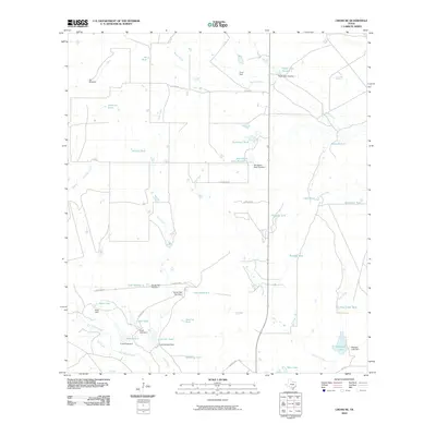
2010 Map of Cross NE
USGS Topo · Published 2010About this map
Macho Creek and San Miguel Creek carve through this section of the South Texas brush country, where water management is the primary shaper of the landscape. The distribution of small earthen reservoirs, or tanks, reveals a ranching economy reliant on artificial water sources. Named landmarks like Vat Windmill, Vat Tank, and Brahma Tank point to a history of livestock operations, while larger developments such as Peeler Lake Number 1 and Strickland Lake Number 1 indicate more extensive hydraulic engineering. A sparse network of county roads, including Strickland Rd and Thompson Rd, connects these isolated water points across the drainage basins of Live Oak Creek and La Jarita Creek.
Find a feature on this map
45 named features on this map. Tap any name to fly to it.
Don’t see what you’re looking for? This feature index may not catch every label — zoom into the map to look around manually.
Map Details
Editions of this 2010 Cross NE Map
This is the sole edition of this map. No revisions or reprints were ever made.
Other maps of this area

1925 · Crowther No. 3
USGS Topo · 1:48,000

1930 · Whitsett
USGS Topo · 1:62,500

1942 · Whitsett
USGS Topo · 1:62,500

1953 · Crystal City
USGS Topo · 1:250,000

1955 · Crystal City
USGS Topo · 1:250,000

1956 · Pleasanton
USGS Topo · 1:62,500

1956 · Jourdanton
USGS Topo · 1:62,500

1956 · Franklin Settlement
USGS Topo · 1:62,500

1961 · Crystal City
USGS Topo · 1:250,000
1965 · Caballos Creek
USGS Topo · 1:24,000