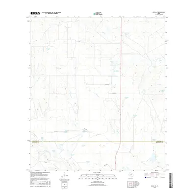
2016 Map of Cross NE
USGS Topo · Published 2016About this map
Peeler Lake Number 1 and a dense network of ranch tanks define this landscape on the border of Atascosa and McMullen Counties. The terrain is shaped by the drainage patterns of San Miguel Cr and its tributaries, including La Jarita Cr and Clear Cr, which sustain a variety of water sources like Strickland Lake Number 1 and Maspero Lake. The road system is largely rural and utility-focused, following property lines and creek beds via routes such as Strickland Rd and Countiss Rd. This 2016 survey reflects the specialized water management infrastructure required for South Texas ranching, where named tanks such as Vat Tank, Javelina Tank, and Sacatosa Tank provide critical water points across the brush country. These features, combined with the county line boundary, illustrate the intersection of local hydrology and administrative divisions in this sparsely settled region.
Find a feature on this map
38 named features on this map. Tap any name to fly to it.
Don’t see what you’re looking for? This feature index may not catch every label — zoom into the map to look around manually.
Map Details
Editions of this 2016 Cross NE Map
This is the sole edition of this map. No revisions or reprints were ever made.
Other maps of this area

1925 · Crowther No. 3
USGS Topo · 1:48,000

1930 · Whitsett
USGS Topo · 1:62,500

1942 · Whitsett
USGS Topo · 1:62,500

1953 · Crystal City
USGS Topo · 1:250,000

1955 · Crystal City
USGS Topo · 1:250,000

1956 · Pleasanton
USGS Topo · 1:62,500

1956 · Jourdanton
USGS Topo · 1:62,500

1956 · Franklin Settlement
USGS Topo · 1:62,500

1961 · Crystal City
USGS Topo · 1:250,000
1965 · Caballos Creek
USGS Topo · 1:24,000