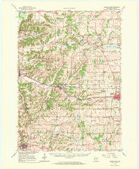
1962 Map of Cross Plains
USGS Topo · Published 1971About this map
Mt Horeb and Cross Plains anchor this 1962 topographical study of western Dane County, depicting a landscape defined by its glacial heritage and agrarian roots. The region is bisected by the Chicago Milwaukee St Paul and Pacific railroad, which follows the winding course of Black Earth Creek through the central valley. Notable scientific and cultural landmarks include the Pine Bluff Observatory and the Radio Tower (WISC-TV) near Madison, alongside localized features like the Richardson Cave and the Drive-in Theater near Middleton.
Find a feature on this map
83 named features on this map. Tap any name to fly to it.
Don’t see what you’re looking for? This feature index may not catch every label — zoom into the map to look around manually.
Map Details
Editions of this 1962 Cross Plains Map
2 editions found
Other maps of this area

1889 · Evansville
USGS Topo · 1:62,500

1890 · Madison
USGS Topo · 1:62,500

1892 · Madison
USGS Topo · 1:62,500

1894 · Evansville
USGS Topo · 1:62,500

1895 · Baraboo
USGS Topo · 1:62,500

1901 · Denzer
USGS Topo · 1:62,500

1901 · Poynette
USGS Topo · 1:62,500

1904 · Madison
USGS Topo · 1:62,500

1906 · Evansville
USGS Topo · 1:62,500

1906 · Madison
USGS Topo · 1:62,500