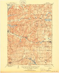
1909 Map of Cross Plains
USGS Topo · Published 1950About this map
Black Earth Creek winds through the driftless-area topography of western Dane County, anchoring a landscape defined by small agricultural hamlets and early rail corridors. Surveyed in the first decade of the 1900s, the map reveals the distinct settlement patterns of townships like Roxbury and Springfield, where German and Scandinavian immigrant communities established landmarks such as Ashton Church and the Lutheran Church. The Chicago Milwaukee and St Paul Railway provides the primary industrial spine, connecting Black Earth and Cross Plains to the developing rail hub at Middleton Junction. To the south, the headwaters of the Sugar River and the undulating terrain near Mt Horeb reflect the transition from the glaciated plains toward the more varied elevations of Table Bluff and Lutheran Hill. This period captures the region just as the village of Middleton was emerging as a significant local center, while smaller stops like Klevenville and Riley served as vital links for rural commerce.
Find a feature on this map
42 named features on this map. Tap any name to fly to it.
Don’t see what you’re looking for? This feature index may not catch every label — zoom into the map to look around manually.
Map Details
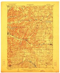
Editions of this 1909 Cross Plains Map
4 editions found

Other maps of this area

1889 · Evansville
USGS Topo · 1:62,500

1890 · Madison
USGS Topo · 1:62,500

1892 · Madison
USGS Topo · 1:62,500

1894 · Evansville
USGS Topo · 1:62,500

1895 · Baraboo
USGS Topo · 1:62,500

1901 · Denzer
USGS Topo · 1:62,500

1901 · Poynette
USGS Topo · 1:62,500

1904 · Madison
USGS Topo · 1:62,500

1906 · Evansville
USGS Topo · 1:62,500

1906 · Madison
USGS Topo · 1:62,500