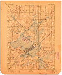
1904 Map of Madison
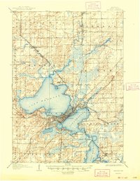
USGS Topo · Published 1954About this map
Madison is defined by its isthmus between Lake Mendota and Lake Monona at the start of the 20th century. The city core is anchored by the University of Wisconsin and the state capitol area, while the surrounding landscape reveals early residential nodes and institutions such as the State Hospital for the Insane and the Monona Assembly. Transportation networks of the Chicago Milwaukee and St Paul Ry and the Chicago and Northwestern Ry radiate from the city center, connecting outlying villages like Waunakee and Mc Farland. The Yahara River chain of lakes dominates the geography, with smaller lakeside developments like Tonyawatha and Ethelwyn Park beginning to dot the shorelines of Lake Waubesa and Lake Wingra. Land use outside the city limits remains largely agricultural across townships like Burke and Fitchburg.
Find a feature on this map
53 named features on this map. Tap any name to fly to it.
Don’t see what you’re looking for? This feature index may not catch every label — zoom into the map to look around manually.
Map Details
Editions of this 1904 Madison Map
This is the sole edition of this map. No revisions or reprints were ever made.
Historical Maps of Madison Through Time
8 maps found