
1890 Map of Madison
USGS Topo · Published 1890About this map
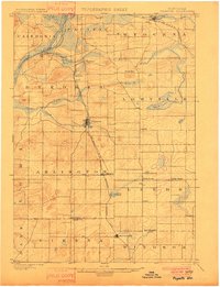
The Isthmus of Madison is the central hub of this late-nineteenth-century survey, flanked by the expansive waters of Lake Mendota and Lake Monona. During this era of rapid expansion, the city’s layout appears as a dense gridiron surrounded by smaller agrarian settlements like Pheasant Branch and Mac Farland. A complex web of rail infrastructure, including the Chicago and Northwestern Railroad and the Chicago Milwaukee and St. Paul Railroad, converges on the capital, highlighting its role as a regional transport nexus before the heavy urbanization of the twentieth century.
Find a feature on this map
31 named features on this map. Tap any name to fly to it.
Don’t see what you’re looking for? This feature index may not catch every label — zoom into the map to look around manually.
Map Details
Editions of this 1890 Madison Map
This is the sole edition of this map. No revisions or reprints were ever made.
Other maps of this area

1889 · Evansville
USGS Topo · 1:62,500

1890 · Sun Prairie
USGS Topo · 1:62,500

1890 · Stoughton
USGS Topo · 1:62,500

1892 · Madison
USGS Topo · 1:62,500

1894 · Evansville
USGS Topo · 1:62,500

1895 · Baraboo
USGS Topo · 1:62,500

1896 · Sun Prairie
USGS Topo · 1:62,500
1901 · Poynette
USGS Topo · 1:62,500

1904 · Madison
USGS Topo · 1:62,500

1905 · Sun Prairie
USGS Topo · 1:62,500