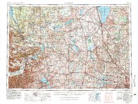
1957 Map of Madison
USGS Topo · Published 1983About this map
Lake Winnebago dominates the northeastern corner of this regional landscape, where the city of Fond du Lac and neighboring North Fond du Lac serve as anchors for the Fox River Valley's industrial and agricultural reach. To the west, the Baraboo Range rises as a distinct geological landmark, overlooking the sprawl of the Badger Ammunition Plant and the recreational waters of Lake Wisconsin. The map detail reveals a densely interconnected network of small towns and rural post offices like Friesland, Pickett, and Dalton, all linked by the Chicago & North Western and Chicago Milwaukee St Paul & Pacific railroads.
Find a feature on this map
291 named features on this map. Tap any name to fly to it.
Don’t see what you’re looking for? This feature index may not catch every label — zoom into the map to look around manually.
Map Details
Editions of this 1957 Madison Map
3 editions found

Other maps of this area

1889 · Evansville
USGS Topo · 1:62,500

1890 · Madison
USGS Topo · 1:62,500

1890 · Sun Prairie
USGS Topo · 1:62,500

1890 · Stoughton
USGS Topo · 1:62,500

1891 · Waterloo
USGS Topo · 1:62,500

1891 · Koshkonong
USGS Topo · 1:62,500

1891 · Bayview
USGS Topo · 1:62,500

1891 · Muskego
USGS Topo · 1:62,500

1892 · Milwaukee
USGS Topo · 1:62,500

1892 · Waukesha
USGS Topo · 1:62,500