
1892 Map of Waukesha
USGS Topo · Published 1892About this map
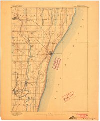
The Waukesha area in the early 1890s appears as a landscape defined by its burgeoning rail corridors and the branching headwaters of the Fox River and Menomonee River. This survey, conducted under director J.W. Powell, illustrates the dense network of early Wisconsin transit, where the Chicago Milwaukee and St Paul Railroad and the Chicago and North Western Railroad intersect at vital rural hubs like Brookfield Junction.
Find a feature on this map
45 named features on this map. Tap any name to fly to it.
Don’t see what you’re looking for? This feature index may not catch every label — zoom into the map to look around manually.
Map Details
Editions of this 1892 Waukesha Map
This is the sole edition of this map. No revisions or reprints were ever made.
Other maps of this area

1891 · Bayview
USGS Topo · 1:62,500

1891 · Muskego
USGS Topo · 1:62,500

1892 · Milwaukee
USGS Topo · 1:62,500

1892 · Oconomowoc
USGS Topo · 1:62,500
1892 · Port Washington
USGS Topo · 1:62,500

1892 · Eagle
USGS Topo · 1:62,500

1894 · Eagle
USGS Topo · 1:62,500

1897 · Eagle
USGS Topo · 1:62,500

1901 · Milwaukee
USGS Topo · 1:62,500

1901 · Waukesha
USGS Topo · 1:62,500