
1891 Map of Bayview
USGS Topo · Published 1891About this map
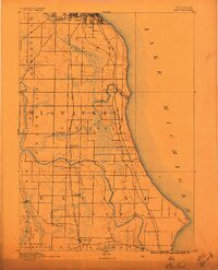
Lake Michigan dominates the eastern boundary of this 1890 survey, showing the coastal landscape of southern Wisconsin before modern industrial expansion. The terrain is defined by the winding course of the Root River and Oak Creek, which cut through the agricultural lands of Racine County and Milwaukee County. A strong industrial spine is already visible in the late nineteenth century, as the Chicago and Northwestern Railroad and the Chicago Milwaukee and St. Paul Railroad run parallel to the shore, connecting the smaller inland settlements to the lakefront. Small rural hubs such as Paynesville, Oakwood, and Caledonia serve as vital centers for the surrounding farming communities. To the south, Franksville and Thomsonville mark the transition toward the open prairies of Mt. Pleasant and Yorkville, offering a detailed view of the region's early transportation network and primary drainage patterns.
Find a feature on this map
24 named features on this map. Tap any name to fly to it.
Don’t see what you’re looking for? This feature index may not catch every label — zoom into the map to look around manually.
Map Details
Editions of this 1891 Bayview Map
2 editions found
Other maps of this area

1891 · Muskego
USGS Topo · 1:62,500

1892 · Milwaukee
USGS Topo · 1:62,500

1892 · Waukesha
USGS Topo · 1:62,500

1892 · Racine
USGS Topo · 1:62,500

1893 · Silver Lake
USGS Topo · 1:62,500

1901 · Milwaukee
USGS Topo · 1:62,500

1901 · Waukesha
USGS Topo · 1:62,500

1901 · Bayview
USGS Topo · 1:62,500

1901 · Muskego
USGS Topo · 1:62,500

1905 · Racine
USGS Topo · 1:62,500