
1901 Map of Waukesha
USGS Topo · Published 1901About this map
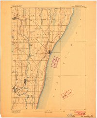
Waukesha anchors the southwestern corner of this survey, which captures the suburban and agricultural landscape west of Milwaukee at the turn of the century. The region is defined by a dense network of competing rail lines, including the Chicago Milwaukee and St. Paul Railroad and the Wisconsin Central Railroad (Main Line). These tracks connect numerous small crossroads and rail stops like Duplainville, Brookfield, and Elm Grove. The mapping reveals the transition from early rural settlements to industrializing centers, with clusters of development at Menominee Falls and Wauwatosa.
Find a feature on this map
60 named features on this map. Tap any name to fly to it.
Don’t see what you’re looking for? This feature index may not catch every label — zoom into the map to look around manually.
Map Details
Editions of this 1901 Waukesha Map
This is the sole edition of this map. No revisions or reprints were ever made.
Other maps of this area

1891 · Bayview
USGS Topo · 1:62,500

1891 · Muskego
USGS Topo · 1:62,500

1892 · Milwaukee
USGS Topo · 1:62,500

1892 · Waukesha
USGS Topo · 1:62,500

1892 · Oconomowoc
USGS Topo · 1:62,500
1892 · Port Washington
USGS Topo · 1:62,500

1892 · Eagle
USGS Topo · 1:62,500

1894 · Eagle
USGS Topo · 1:62,500

1897 · Eagle
USGS Topo · 1:62,500

1901 · Milwaukee
USGS Topo · 1:62,500