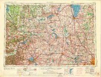
1957 Map of Madison
USGS Topo · Published 1976About this map
The Wisconsin River carves through the central landscape of this mid-century survey, anchoring a region defined by the glacial legacy of the Kettle Moraine. Centered on Madison, the map documents the dense cluster of the Four Lakes—including Lake Mendota and Lake Monona—long before modern suburban sprawl fully connected these drainage basins. To the east, the vast expanse of Lake Winnebago and the marshes of the Horicon National Wildlife Refuge dominate the drainage patterns of the Fox River.
Find a feature on this map
218 named features on this map. Tap any name to fly to it.
Don’t see what you’re looking for? This feature index may not catch every label — zoom into the map to look around manually.
Map Details
Editions of this 1957 Madison Map
3 editions found

Other maps of this area

1889 · Evansville
USGS Topo · 1:62,500

1890 · Madison
USGS Topo · 1:62,500

1890 · Sun Prairie
USGS Topo · 1:62,500

1890 · Stoughton
USGS Topo · 1:62,500

1891 · Waterloo
USGS Topo · 1:62,500

1891 · Koshkonong
USGS Topo · 1:62,500

1891 · Bayview
USGS Topo · 1:62,500

1891 · Muskego
USGS Topo · 1:62,500

1892 · Milwaukee
USGS Topo · 1:62,500

1892 · Waukesha
USGS Topo · 1:62,500