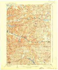
1909 Map of Cross Plains
USGS Topo · Published 1942About this map
Mt Horeb and the surrounding townships of western Dane County are captured here during a period of agricultural stability and early rail expansion. The landscape is defined by the winding valley of Black Earth Creek, which dictates the path of the Chicago Milwaukee and St Paul Rr. Settlement patterns follow these natural corridors, with clusters of activity at Cross Plains and the rail hub at Middleton Junction. To the south, the Chicago and Northwestern Ry cuts through the terrain near Klevenville, supporting the transport of goods from the surrounding farmsteads.
Find a feature on this map
39 named features on this map. Tap any name to fly to it.
Don’t see what you’re looking for? This feature index may not catch every label — zoom into the map to look around manually.
Map Details
Editions of this 1909 Cross Plains Map
4 editions found

Other maps of this area

1889 · Evansville
USGS Topo · 1:62,500

1890 · Madison
USGS Topo · 1:62,500

1892 · Madison
USGS Topo · 1:62,500

1894 · Evansville
USGS Topo · 1:62,500

1895 · Baraboo
USGS Topo · 1:62,500

1901 · Denzer
USGS Topo · 1:62,500

1901 · Poynette
USGS Topo · 1:62,500

1904 · Madison
USGS Topo · 1:62,500

1906 · Evansville
USGS Topo · 1:62,500

1906 · Madison
USGS Topo · 1:62,500