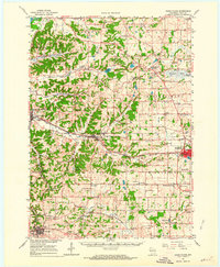
1962 Map of Cross Plains
USGS Topo · Published 1964About this map
Cross Plains and its surrounding townships define this 1962 landscape, where the unglaciated driftless hills meet the glacial plains of western Dane County. The terrain is deeply carved by Black Earth Creek and the Sugar River, supporting a network of agricultural hamlets like Marxville, Pine Bluff, and Klevenville. High points are marked by specialized landmarks, notably the Pine Bluff Observatory and a Radio Tower near the southern boundary. The presence of Richardson Cave and Table Bluff indicates a karst landscape with significant local topography. Transport and commerce revolve around the Chicago Milwaukee St Paul and Pacific rail line, which services the growing villages of Middleton and Mt Horeb. Evidence of early community life remains in the numerous rural cemeteries like Sunning Hill Cem and country churches such as Vermont Ch, while mid-century modernization is visible at the Drive-in Theater and Morey Airport.
Find a feature on this map
78 named features on this map. Tap any name to fly to it.
Don’t see what you’re looking for? This feature index may not catch every label — zoom into the map to look around manually.
Map Details
Editions of this 1962 Cross Plains Map
2 editions found
Other maps of this area

1889 · Evansville
USGS Topo · 1:62,500

1890 · Madison
USGS Topo · 1:62,500

1892 · Madison
USGS Topo · 1:62,500

1894 · Evansville
USGS Topo · 1:62,500

1895 · Baraboo
USGS Topo · 1:62,500

1901 · Denzer
USGS Topo · 1:62,500

1901 · Poynette
USGS Topo · 1:62,500

1904 · Madison
USGS Topo · 1:62,500

1906 · Evansville
USGS Topo · 1:62,500

1906 · Madison
USGS Topo · 1:62,500