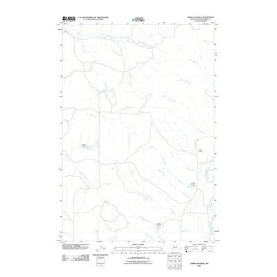
2011 Map of Cross S School
USGS Topo · Published 2011About this map
The Powder River flows along the eastern edge of this landscape in Powder River County, Montana, carving through a region defined by extensive drainage networks and early 21st-century water management. Named creeks like Cross S Creek, Slaughter Creek, and Buffalo Creek weave across the terrain, feeding into the larger river system. This area is punctuated by localized water infrastructure, including the Spear Number 1 Dam, Jurica Number 1 Dam, and Landa Number 2 Dam, which reflect the essential role of water storage in this ranching environment. Transportation is anchored by the Cross S Rd and Powderville West Rd, providing access to the rugged Deep Coulee. The mapping of these features, alongside the numerous smaller tributaries like Rough Creek and Crooked Creek, documents a sparsely populated but carefully managed Montana landscape.
Find a feature on this map
19 named features on this map. Tap any name to fly to it.
Don’t see what you’re looking for? This feature index may not catch every label — zoom into the map to look around manually.
Map Details
Editions of this 2011 Cross S School Map
This is the sole edition of this map. No revisions or reprints were ever made.
Other maps of this area

1954 · Ekalaka
USGS Topo · 1:250,000

1956 · Ekalaka
USGS Topo · 1:250,000

1958 · Ekalaka
USGS Topo · 1:250,000

1965 · Ekalaka
USGS Topo · 1:250,000

1973 · Cross S School
USGS Topo · 1:24,000
1973 · Witcher Reservoir
USGS Topo · 1:24,000

1973 · Moonlight Creek
USGS Topo · 1:24,000
1973 · Rattlesnake Hill
USGS Topo · 1:24,000

1973 · Hawkey Creek
USGS Topo · 1:24,000
1973 · Johnnie Creek
USGS Topo · 1:24,000