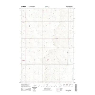
2014 Map of Cross S School
USGS Topo · Published 2014About this map
Cross S School stands as a primary landmark in this corner of Powder River County, where the landscape is defined by the complex drainage network of the Powder River basin. The area is characterized by numerous seasonal and perennial watercourses, including the E Fork Cross S Cr, Slaughter Cr, and Buffalo Cr, which carve through the terrain to form features like Deep Coulee. The presence of Cross S Rd and Powderville W Rd indicates the primary corridors of travel through these sections of T1S and T2S. This map illustrates the intersection of rural education and ranching infrastructure, capturing the layout of a landscape where namesake creeks like Johnnie Cr and Road Cr serve as vital geographic markers for local residents and land managers.
Find a feature on this map
21 named features on this map. Tap any name to fly to it.
Don’t see what you’re looking for? This feature index may not catch every label — zoom into the map to look around manually.
Map Details
Editions of this 2014 Cross S School Map
This is the sole edition of this map. No revisions or reprints were ever made.
Other maps of this area

1954 · Ekalaka
USGS Topo · 1:250,000

1956 · Ekalaka
USGS Topo · 1:250,000

1958 · Ekalaka
USGS Topo · 1:250,000

1965 · Ekalaka
USGS Topo · 1:250,000

1973 · Cross S School
USGS Topo · 1:24,000
1973 · Witcher Reservoir
USGS Topo · 1:24,000

1973 · Moonlight Creek
USGS Topo · 1:24,000
1973 · Rattlesnake Hill
USGS Topo · 1:24,000

1973 · Hawkey Creek
USGS Topo · 1:24,000
1973 · Johnnie Creek
USGS Topo · 1:24,000