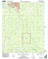
2002 Map of Crossett South
USGS Topo · Published 2003About this map
Crossett and South Crossett define the northern landscape of this Arkansas-Louisiana borderlands survey. The area is characterized by a transition from the urban grid and industrial features like the Sewage Pond and Lucas Pond into the dense woodlands of the Quachita National Forest. This forest tract includes the Hickory Grove Picnic Area and is monitored by a Lookout Tower, reflecting a mid-century reliance on fire watch infrastructure. To the south and west, the terrain is marked by timberlands and a network of creeks, including Snake Creek and White Creek, which flow toward the state line.
Find a feature on this map
26 named features on this map. Tap any name to fly to it.
Don’t see what you’re looking for? This feature index may not catch every label — zoom into the map to look around manually.
Map Details
Editions of this 2002 Crossett South Map
This is the sole edition of this map. No revisions or reprints were ever made.
Other maps of this area

1934 · Felsenthal
USGS Topo · 1:62,500

1935 · Naff
USGS Topo · 1:62,500

1935 · Haile
USGS Topo · 1:62,500

1937 · Felsenthal
USGS Topo · 1:62,500

1938 · Felsenthal
USGS Topo · 1:62,500

1939 · Felsenthal
USGS Topo · 1:62,500

1953 · Greenwood
USGS Topo · 1:250,000

1953 · El Dorado
USGS Topo · 1:250,000

1955 · Jackson
USGS Topo · 1:250,000

1955 · Shreveport
USGS Topo · 1:250,000