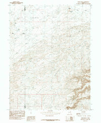
1985 Map of Crow Knoll
USGS Topo · Published 1985About this map
The border of Duchesne and Uintah counties divides this high desert landscape, which in the mid-1980s was characterized by water management for livestock and the expansion of energy infrastructure. An extensive Pipeline network cuts across the terrain, indicating the region's industrial importance during this period. Much of the local geography is defined by a series of knolls and flats, most notably the wide expanse of Eightmile Flat and the prominent Crow Knoll. Water sources are sparse, consisting of seasonal drainages and man-made collections such as Kilroy Reservoir, Coleman Reservoir, and Sheep Reservoir. These landmarks, along with Desert Spring, suggest a landscape shaped by the practical needs of ranching and the demands of desert survival in a region where names like Sheep Wash and Antelope Knolls reflect the local fauna.
Find a feature on this map
19 named features on this map. Tap any name to fly to it.
Don’t see what you’re looking for? This feature index may not catch every label — zoom into the map to look around manually.
Map Details
Editions of this 1985 Crow Knoll Map
This is the sole edition of this map. No revisions or reprints were ever made.
Other maps of this area

1885 · East Tavaputs
USGS Topo · 1:250,000

1885 · Ashley
USGS Topo · 1:250,000

1885 · Uinta
USGS Topo · 1:250,000

1886 · Price River
USGS Topo · 1:250,000

1896 · Price River
USGS Topo · 1:250,000

1917 · Vernal
USGS Topo · 1:125,000

1939 · Duchesne
USGS Topo · 1:125,000

1953 · Nutters Hole
USGS Topo · 1:62,500

1954 · Salt Lake City
USGS Topo · 1:250,000

1954 · Vernal
USGS Topo · 1:250,000