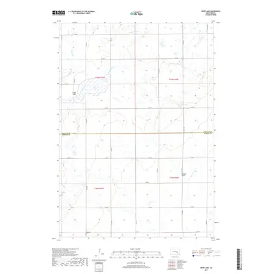
2017 Map of Crow Lake
USGS Topo · Published 2017About this map
Crow Lake and its surrounding prairie wetlands dominate this South Dakota landscape, providing a clear view of the water and drainage patterns in the northern plains. The terrain is defined by the headwaters of several drainages, including Smith Cr and the East Fork Smith Creek in the north, while the southern section is drained by the W Br Firesteel Cr. Historically significant markers for genealogists and local historians include the Underwood Cem located near the southern boundary and the named area of Hawkeye Valley to the east. The map illustrates a strictly organized grid of section lines and local roads like 372nd Ave and Co Rd 8, which follow the Jerauld County and Aurora County line, reflecting the systematic agricultural development of this rural region.
Find a feature on this map
31 named features on this map. Tap any name to fly to it.
Don’t see what you’re looking for? This feature index may not catch every label — zoom into the map to look around manually.
Map Details
Editions of this 2017 Crow Lake Map
This is the sole edition of this map. No revisions or reprints were ever made.
Other maps of this area

1941 · Kimball North
USGS Topo · 1:62,500

1942 · Crow Lake
USGS Topo · 1:62,500

1951 · Kimball North
USGS Topo · 1:62,500

1953 · Huron
USGS Topo · 1:250,000

1954 · Huron
USGS Topo · 1:250,000

1955 · Mitchell
USGS Topo · 1:250,000

1959 · Mitchell
USGS Topo · 1:250,000

1973 · Wessington Springs
USGS Topo · 1:24,000
1973 · Wessington Springs SW
USGS Topo · 1:24,000
1973 · Gannvalley SE
USGS Topo · 1:24,000
Featured Places
- Crow Lake, SD
- Crow Lake Township, SD
- Patten Township, SD
- Pleasant Valley Township, SD
- Anina Township, SD