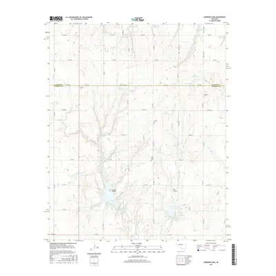
2016 Map of Crowder Lake
USGS Topo · Published 2016About this map
Crowder Lake and the rugged drainage of Cobb Cr define this landscape along the border of Custer and Washita Counties. The map reveals a highly managed water system dominated by numerous man-made reservoirs and catchment sites, including the Worth Richmond Lake and the numeric 149006 Reservoir, which support the local agricultural economy. The terrain is marked by distinctive features like Possum Hollow and Dry Canyon, illustrating the varied topography of this Oklahoma region.
Find a feature on this map
45 named features on this map. Tap any name to fly to it.
Don’t see what you’re looking for? This feature index may not catch every label — zoom into the map to look around manually.
Map Details
Editions of this 2016 Crowder Lake Map
This is the sole edition of this map. No revisions or reprints were ever made.
Other maps of this area

1955 · Clinton
USGS Topo · 1:250,000

1956 · Cordell
USGS Topo · 1:62,500

1957 · Clinton
USGS Topo · 1:250,000

1957 · Clinton
USGS Topo · 1:62,500

1961 · Eakly
USGS Topo · 1:62,500

1964 · Weatherford
USGS Topo · 1:62,500

1976 · Clinton SE
USGS Topo · 1:24,000
1983 · Corn
USGS Topo · 1:24,000
1983 · Indianapolis
USGS Topo · 1:24,000

1983 · Cloud Chief
USGS Topo · 1:24,000