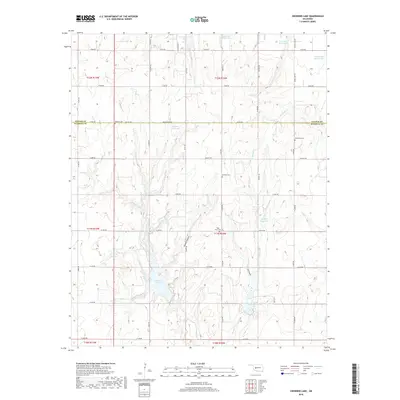
2018 Map of Crowder Lake
USGS Topo · Published 2018About this map
The Oklahoma prairie at the border of Custer and Washita counties is defined by a network of drainage creeks and water management reservoirs. Crowder Lake and Worth Richmond Lake sit in the southern half of the map, surrounded by a grid of section-line roads like Washita Rd and Dallas Rd. This landscape reflects a century of agricultural development, where small drainages like Cobb Cr and Fivemile Cr have been augmented by numerous reservoirs including Sportsman Lake, Hunnicutt Reservoir, and Crissman Reservoir.
Find a feature on this map
50 named features on this map. Tap any name to fly to it.
Don’t see what you’re looking for? This feature index may not catch every label — zoom into the map to look around manually.
Map Details
Editions of this 2018 Crowder Lake Map
This is the sole edition of this map. No revisions or reprints were ever made.
Other maps of this area

1955 · Clinton
USGS Topo · 1:250,000

1956 · Cordell
USGS Topo · 1:62,500

1957 · Clinton
USGS Topo · 1:250,000

1957 · Clinton
USGS Topo · 1:62,500

1961 · Eakly
USGS Topo · 1:62,500

1964 · Weatherford
USGS Topo · 1:62,500

1976 · Clinton SE
USGS Topo · 1:24,000
1983 · Corn
USGS Topo · 1:24,000
1983 · Indianapolis
USGS Topo · 1:24,000

1983 · Cloud Chief
USGS Topo · 1:24,000