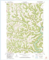
1983 Map of Crowley Ridge
USGS Topo · Published 1983About this map
Crowley Ridge and Shanghai Ridge dominate the dissected upland landscape of Crawford County, where steep-sided valleys like Haney Valley and Citron Valley reveal the area's intricate drainage patterns. The Kickapoo River meanders sharply in the southeast corner, accompanied by the distinct oxbow of Old Kickapoo, illustrating the dynamic nature of the river's floodplain over time. Small, localized settlements such as Shanghai and the northern edge of Wauzeka are visible, alongside scattered rural landmarks including the Stewart Cem and Shanghai Ridge Cem.
Find a feature on this map
42 named features on this map. Tap any name to fly to it.
Don’t see what you’re looking for? This feature index may not catch every label — zoom into the map to look around manually.
Map Details
Editions of this 1983 Crowley Ridge Map
This is the sole edition of this map. No revisions or reprints were ever made.
Other maps of this area

1903 · Waukon
USGS Topo · 1:125,000

1924 · Gays Mills
USGS Topo · 1:62,500

1926 · Gays Mills
USGS Topo · 1:62,500

1926 · Wauzeka
USGS Topo · 1:62,500

1929 · Ferryville
USGS Topo · 1:62,500

1929 · Prairie Du Chien
USGS Topo · 1:62,500

1932 · Ferryville
USGS Topo · 1:62,500

1932 · Prairie Du Chien
USGS Topo · 1:62,500

1958 · La Crosse
USGS Topo · 1:250,000

1961 · La Crosse
USGS Topo · 1:250,000