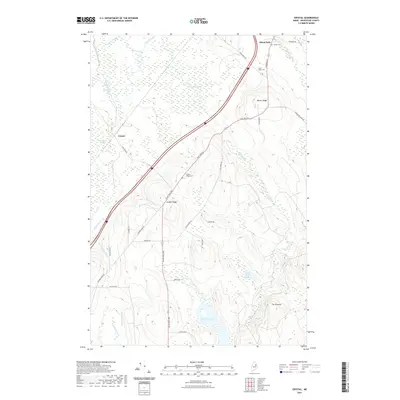
2021 Map of Crystal
USGS Topo · Published 2021About this map
Island Falls and the surrounding Aroostook County forestland define this 2021 landscape, where the northern end of the interstate corridor cuts through the timber and wetlands of central Maine. The settlement of Crystal sits near the expansive Thousand Acre Bog, a significant hydrologic feature drained by Fish Stream and Crystal Brook. To the southeast, the terrain rises toward Barker Ridge and The Pinnacle, while numerous small drainages like Lufman Brook and Sly Brook feed into Macwahoc Lake. Local family history is centered around several burial grounds, including the Village Cem, Saint Agnes Cem, and Golden Ridge Cem, providing valuable points of reference for genealogists tracing residents of these rural townships. This map documents a modern snapshot of a region still defined by its complex network of brooks and the legacy of its logging roads and small hill-ridge settlements.
Find a feature on this map
40 named features on this map. Tap any name to fly to it.
Don’t see what you’re looking for? This feature index may not catch every label — zoom into the map to look around manually.
Map Details
Editions of this 2021 Crystal Map
This is the sole edition of this map. No revisions or reprints were ever made.
Other maps of this area

1937 · Smyrna Mills
USGS Topo · 1:62,500

1940 · Island Falls
USGS Topo · 1:62,500

1940 · Sherman
USGS Topo · 1:62,500

1941 · Mattawamkeag Lake
USGS Topo · 1:62,500

1942 · Island Falls
USGS Topo · 1:62,500

1942 · Sherman
USGS Topo · 1:62,500

1943 · Mattawamkeag Lake
USGS Topo · 1:62,500

1954 · Presque Isle
USGS Topo · 1:250,000

1954 · Millinocket
USGS Topo · 1:250,000

1955 · Smyrna Mills
USGS Topo · 1:62,500