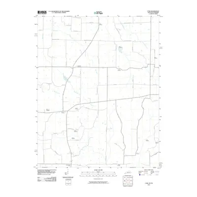
2010 Map of Cuba
USGS Topo · Published 2010About this map
Dukedom Post Office sits at the southern edge of this Graves County landscape, marking the crossing into Tennessee along State Line Rd. The terrain is defined by a dense network of country roads named for early families, such as Curtsinger Rd, Woodson Rd, and Stubblefield Rd, which connect small farmsteads and agricultural plots. The land is drained by several meandering watercourses, including Barn Creek, Brush Creek, and Little Cypress Creek, which flow through the patchwork of fields.
Find a feature on this map
53 named features on this map. Tap any name to fly to it.
Don’t see what you’re looking for? This feature index may not catch every label — zoom into the map to look around manually.
Map Details
Editions of this 2010 Cuba Map
This is the sole edition of this map. No revisions or reprints were ever made.
Other maps of this area

1936 · Farmington
USGS Topo · 1:24,000

1951 · Farmington
USGS Topo · 1:24,000

1952 · Mayfield
USGS Topo · 1:24,000

1952 · Dublin
USGS Topo · 1:24,000

1952 · Cuba
USGS Topo · 1:24,000

1952 · Water Valley
USGS Topo · 1:24,000

1952 · Mayfield
USGS Topo · 1:62,500

1952 · Water Valley
USGS Topo · 1:62,500
1952 · Lynnville
USGS Topo · 1:24,000

1956 · Mc Connell
USGS Topo · 1:24,000