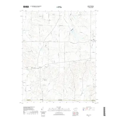
2019 Map of Cuba
USGS Topo · Published 2019About this map
Cuba and Pilot Oak anchor this rural landscape in the southwestern corner of Graves County, Kentucky, where the landscape transitions across the Kentucky and Tennessee state line. The area is defined by a dense network of local cemeteries and country churches, such as Little Bethel Cem and Cuba Church of Christ, indicating long-established family ties and community nodes. Waterways like Obion Cr and Bayou de Chien wind through the terrain, with Blackamore Cr and Knob Cr draining the southern reaches toward Dukedom. The map reveals a high concentration of named roads, including Waggoner Bottom Rd and State Line Rd, which connect dozens of family-named landmarks like Thompson Cem and Bowden Cem. This detailed survey is particularly valuable for genealogists tracing ancestors in the Jackson Purchase region, where small burial plots and churchyards often serve as the primary physical records of nineteenth and twentieth-century settlement patterns.
Find a feature on this map
81 named features on this map. Tap any name to fly to it.
Don’t see what you’re looking for? This feature index may not catch every label — zoom into the map to look around manually.
Map Details
Editions of this 2019 Cuba Map
This is the sole edition of this map. No revisions or reprints were ever made.
Other maps of this area

1936 · Farmington
USGS Topo · 1:24,000

1951 · Farmington
USGS Topo · 1:24,000

1952 · Mayfield
USGS Topo · 1:24,000

1952 · Dublin
USGS Topo · 1:24,000

1952 · Cuba
USGS Topo · 1:24,000

1952 · Water Valley
USGS Topo · 1:24,000

1952 · Mayfield
USGS Topo · 1:62,500

1952 · Water Valley
USGS Topo · 1:62,500
1952 · Lynnville
USGS Topo · 1:24,000

1956 · Mc Connell
USGS Topo · 1:24,000