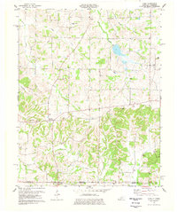
1977 Map of Cuba
USGS Topo · Published 1977About this map
Cuba and the rural crossroads of Pilot Oak anchor this landscape along the Kentucky Tennessee state line. The topography is defined by the winding paths of Brush Creek and Obion Creek, which drain a region heavily dotted with family cemeteries and country churches. The density of sites like Pinson Cem, Thompson Cem, and Hainline Cem provides a detailed genealogical map of the families who settled this portion of Graves County. To the south, the community of Dukedom straddles the border, illustrating how state lines often bisected small agricultural hubs. The presence of Little Bethel Ch and Poyners Chapel suggests a long-standing social network tied to these rural congregations, while the Gravel Pit near Obion Creek hints at the local extraction that supported regional infrastructure.
Find a feature on this map
36 named features on this map. Tap any name to fly to it.
Don’t see what you’re looking for? This feature index may not catch every label — zoom into the map to look around manually.
Map Details
Editions of this 1977 Cuba Map
This is the sole edition of this map. No revisions or reprints were ever made.
Other maps of this area

1936 · Farmington
USGS Topo · 1:24,000

1951 · Farmington
USGS Topo · 1:24,000

1952 · Mayfield
USGS Topo · 1:24,000

1952 · Dublin
USGS Topo · 1:24,000

1952 · Cuba
USGS Topo · 1:24,000

1952 · Water Valley
USGS Topo · 1:24,000

1952 · Mayfield
USGS Topo · 1:62,500

1952 · Water Valley
USGS Topo · 1:62,500
1952 · Lynnville
USGS Topo · 1:24,000

1956 · Mc Connell
USGS Topo · 1:24,000