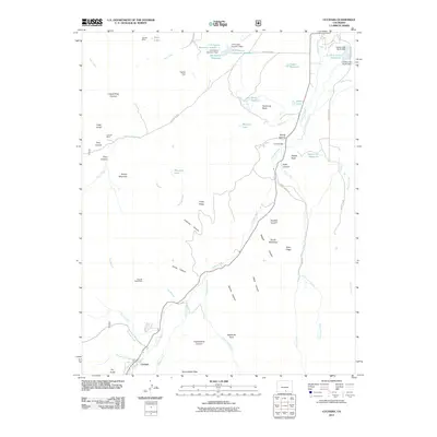
2011 Map of Cuchara
USGS Topo · Published 2011About this map
The Cucharas River valley in Huerfano County is defined by its complex irrigation infrastructure and vertical topography, anchored by the settlement of Cuchara. This 2011 survey illustrates the elaborate network of water management essential to this high-altitude landscape, including the Spanish Peaks Ditch, Butte Ditch, and Dyer DITCH. These systems feed numerous storage bodies like the La Veta Town Reservoir and the H R Carson Reservoir Number 1. Historical mining activity is marked by the Spanish Peaks Mine, Wonder Mine, and Linscott Mine, scattered among dramatic landforms like Goemmer Butte and Kruger Mountain. The map also captures several named canyons, such as Echo Canyon and Cottonwood Canyon, alongside distinctive rock formations like Profile Rock and Sawtooth Rock, which served as important landmarks for early travelers and surveyors in the Sangre de Cristo foothills.
Find a feature on this map
67 named features on this map. Tap any name to fly to it.
Don’t see what you’re looking for? This feature index may not catch every label — zoom into the map to look around manually.
Map Details
Editions of this 2011 Cuchara Map
This is the sole edition of this map. No revisions or reprints were ever made.
Other maps of this area

1889 · Huerfano Park
USGS Topo · 1:125,000

1891 · Walsenburg
USGS Topo · 1:125,000

1891 · Spanish Peaks
USGS Topo · 1:125,000

1892 · Huerfano Park
USGS Topo · 1:125,000

1893 · Spanish Peaks
USGS Topo · 1:125,000

1894 · Walsenburg
USGS Topo · 1:125,000

1895 · Spanish Peaks
USGS Topo · 1:125,000

1897 · Walsenburg
USGS Topo · 1:125,000

1897 · Spanish Peaks
USGS Topo · 1:125,000

1900 · Spanish Peaks
USGS Topo · 1:125,000