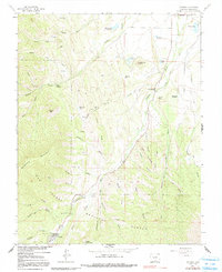
1967 Map of Cuchara
USGS Topo · Published 1986About this map
Cuchara serves as the central anchor of this high-altitude landscape, situated along the Cucharas River within the southern reaches of the San Isabel National Forest. The 1960s terrain is defined by a dense network of steep drainages, including Rilling Canyon and Echo Canyon, which feed into larger water bodies such as Mc Donald Reservoir and Town Lakes. Significant peaks and formations like Raspberry Mountain, Kruger Mtn, and the distinctive Goemmer Butte dominate the horizon, while natural features like Sulphur Springs suggest the local geological character. This topographic study reveals a landscape shaped by early water management, evidenced by numerous ditches and reservoirs like Hayes Res and the Hr Carson Reservoir, supporting a mountain community defined by its proximity to the river and the surrounding peaks of the Sangre de Cristo foothills.
Find a feature on this map
45 named features on this map. Tap any name to fly to it.
Don’t see what you’re looking for? This feature index may not catch every label — zoom into the map to look around manually.
Map Details
Editions of this 1967 Cuchara Map
2 editions found
Other maps of this area

1889 · Huerfano Park
USGS Topo · 1:125,000

1891 · Walsenburg
USGS Topo · 1:125,000

1891 · Spanish Peaks
USGS Topo · 1:125,000

1892 · Huerfano Park
USGS Topo · 1:125,000

1893 · Spanish Peaks
USGS Topo · 1:125,000

1894 · Walsenburg
USGS Topo · 1:125,000

1895 · Spanish Peaks
USGS Topo · 1:125,000

1897 · Walsenburg
USGS Topo · 1:125,000

1897 · Spanish Peaks
USGS Topo · 1:125,000

1900 · Spanish Peaks
USGS Topo · 1:125,000