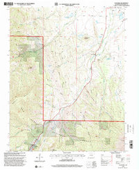
1994 Map of Cuchara
USGS Topo · Published 2001About this map
San Isabel National Forest dominates the terrain of this survey, which captures a landscape defined by sharp topographical relief and the deep incisions of the Cucharas River. The southern portion of the map is punctuated by dramatic geological features like the Devils Stairsteps and Sawtooth Rock, while the northern reaches provide a look at the outskirts of La Veta and the small mountain settlement of Cuchara. Resource extraction and water management are evident throughout the quadrangle, from the Linscott Mine and various prospects tucked into the gulches to the network of reservoirs including the H R Carson Reservoir and Hayes Reservoir. The presence of the Three Bridges along the river and the Gaging Sta further indicates the infrastructure required to manage the mountain drainage systems as they descend from peaks like Raspberry Mountain and Kruger Mountain.
Find a feature on this map
59 named features on this map. Tap any name to fly to it.
Don’t see what you’re looking for? This feature index may not catch every label — zoom into the map to look around manually.
Map Details
Editions of this 1994 Cuchara Map
This is the sole edition of this map. No revisions or reprints were ever made.
Other maps of this area

1889 · Huerfano Park
USGS Topo · 1:125,000

1891 · Walsenburg
USGS Topo · 1:125,000

1891 · Spanish Peaks
USGS Topo · 1:125,000

1892 · Huerfano Park
USGS Topo · 1:125,000

1893 · Spanish Peaks
USGS Topo · 1:125,000

1894 · Walsenburg
USGS Topo · 1:125,000

1895 · Spanish Peaks
USGS Topo · 1:125,000

1897 · Walsenburg
USGS Topo · 1:125,000

1897 · Spanish Peaks
USGS Topo · 1:125,000

1900 · Spanish Peaks
USGS Topo · 1:125,000